Learn to Speak French With Caroline or Anaïs
Friendly - Fun - Functional
Or email: frenchwithcaroline@btinternet.com
Ladybower
Walk
“A Cloudy day walking in the peaks is better than a sunny day in the office”
 |
The ladybower walk is an easy 11 mile walk which takes around 4 hours to complete. This is a full circuit walking along derwant water and Howden reservoir. There are picnic sites at slippery stones and then it's back to Fairholmes car park. |
Getting to Ladybower reservoir from Chesterfield (Post code : S33 0AQ)
From chesterfield take the b6051 through Barlow and up Owler bar. From here follow the b6054 to and through Hathersage. After Hathersage you’ll eventually come to a set of traffic lights with a right turn to Bamford on the A6013. Once you reach the end of this road turn left at the T junction and traffic lights and then the first right over the bridge. This road follows Ladybower reservoir to the Fairholmes car park.
Start at Fairholmes car park (Sat Nav: S33 0AQ)
Parking fees:
£2.50 up to 2 hours
£4.70 all day
There is no charge for disabled permit holders displaying their permit.
It’s worth noting that by paying and displaying when you visit a Seven Trent water site your car parking money helps to maintain and improve the site’s facilities and fund conservation projects.
Walk summary: Mainly flat easy to follow man made wide paths. The walk is suitable for most that have the need for some fresh air and enjoy the beauty of the British countryside. You are however near water and high reservoir walls so extra care is needed with young children.
Guided walks: We have guides available to escort you on your walk. Our guides are very friendly, experienced hill walkers and local residents to the area. They are also highly qualified first aiders. Obviously there is a charge for their time; the more there are of you the cheaper it will be. Click here to arrange your guide – they will plan the walk around you.
We visited on Sunday 26th May 2013 and it was very busy. We arrived at 11.15am and there were no parking spaces left in the car park so we parked in the little area on the right just before the “Slow children and Ducks” sign. OK you may not have to pay and display here but it helps the centre fund their projects.
Quick View of the Ladybower walk.
1. Follow the path indicated dams and follow path to right of first dam.
2. Follow this path all the way to the bridge at slippery stones
3. Cross over bridge.
4. Follow the main path all the way back to the car park
5. Stop to look at the museum
6. After museum take the path signed Fairholmes.
|
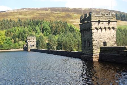
Start of the ladybower walk The start of the walk is in the Fairholmes car park. Walk to where you drove into the car park. On the right hand side of the road at the side of the “hole in the wall shop” you’ll find a path to the dams. Follow the path and cross the flood field to the right hand side of the dam where you’ll find a platform. Here follow the steps to the top and turn left. |
 |
It’s very simple, follow the main cycle route/road all the way round back to the car park. There that wasn’t hard to write!!
However there are a few tweaks I like to make. When you’re nearly at the end of Howden reservoir (walking north) you’ll see a footpath leading to a style down the hill on the edge of the woods in the valley. We usually walk through these woods to slippery stones because no-one else seems to bother and it’s very peaceful. We have had a pic nic in the woods before but on a warm sunny day we prefer to pic nic near the bridge.
Slippery Stones
The large slimy slabs were once the only way of getting across the River Derwent at the northern end of Howden Reservoir. It is now crossed by a packhorse bridge of the same name which was rescued from the submerged village of Derwent. The 17th century stone bridge was classified as an ancient monument so before the village was flooded it was dismantled and transported to the new location. The stones were numbered and put into storage for a number of years before it was reconstructed in 1959 at the new site.
Once you've rested and had a dip - Cross over the bridge and follow the main road (South) back to the Fairholmes car park. The path does follow the River Westend estuary so don't worry too much when you walk away from the main Howden reservoir.
Look out for all the signs explaining where the old village was located to get an idea of what the place looked like in the early 1900’s.
|
I last walked the reservoirs (May 2013) just after the memorial flyover remembering the pilots of The Dam Busters 70 years on. I was lucky enough to be working at Chatsworth House when the planes flew over and got some great photos. I hope you have enjoyed this ladybower walk, I have listed my favourite here. |
 |
Move from our Ladybower walk to our Near Chesterfield Derbyshire homepage