Learn to Speak French With Caroline or Anaïs
Friendly - Fun - Functional
Or email: frenchwithcaroline@btinternet.com
Lose
Hill Walk
“A
Cloudy day walking in the peaks is better than a sunny day in the office”
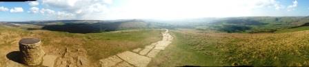
The Great Ridge, Derbyshire
 |
Lose Hill walk. An excellent walk from Castleton in Derbyshire. The walk takes you to the top of Lose Hill, to back tor, mam tor and back to castleton. The decent is awesome. You pass Mam Tor cliff, odin's mine, knowlegates farm and odin sitch. |
"Did your Castleton to lose hill and mam tor walk. It was really good. Thanks for posting"! - Sam (Manchester)
Plan your day for lose hill walk
Start/Parking Castleton Visitor centre grid reference 149 829 Ordnance survey map OL1 and Sat Nav post code S33 8WP
Walk summary: 5 stiles some very thin, mainly across country. There are short stretches on road and there is one very long ascent of around 45 minutes.
Summary: This moderate (12 mile/7 km) walk took me 4 hours steady walking. I started at 09.20 and finished at 13.30. I stopped twice for a brew and once for lunch so I imagine it could be done in 3 hours, but why rush, the views are amazing.
Guided walks: We have guides available to escort you on your walk. Our guides are very friendly, experienced hill walkers/mountain leaders. They are also highly qualified first aiders. Obviously there is a charge for their time; the more there are of you the cheaper it will be. Contact us to arrange a your guide.
Quick instructions - Lose Hill Walk.
A more detailed description follows and I have attached a PDF at the bottom.
Lose Hill Walk is One of my favourite walks in the Peak district.
You could start Lose Hill Walk early in the morning and have lunch and a pint in one of the town’s great pubs. In the afternoon you could then visit Perveril castle or the Devils Arse.
|
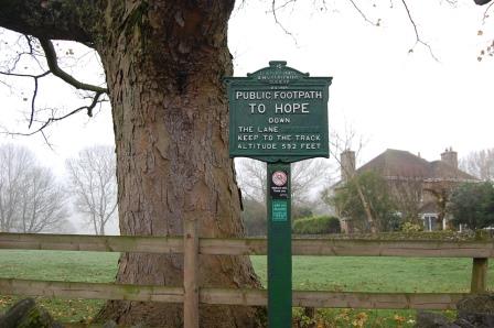
Start Leave the car park and turn left to follow the main road all the way out of Castleton passing the Peak Hotel and the Cheshire cheese pub. You’ll come to a sign on the right hand side (pictured) for the footpath cross country to hope. The path follows the stream (Peakshole Water). |
 |
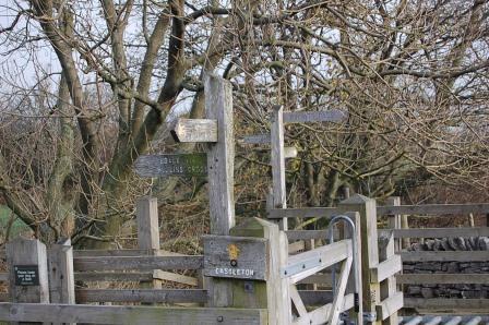
You’ll see a well-marked path which takes you through several stiles, grazing fields and eventually reaches a railway line. Be careful as crossing tracks can be dangerous and it looks like someone has broken the warning light. On the other side follow the path straight on with the stream and the woods on your left. The path will bring you to the road (Pindale road). Turn left crossing the bridge to enter Hope next to the Woodroffe Arms.
The main road through Hope is the A6187, and you’ve just reached it. You need to cross the road to the Spar shop and turn right to Edale road. You’ll see the Old Hall hotel on the corner. Follow Edale road. You’ll pass the Cheshire cheese pub, under the bridge and continue on to Losehill lane. It is a road not one of the earlier footpaths. There is a sign for Losehill House hotel and Spa. Turn left up Losehill lane all the way to a fork in the road. Take the left hand fork and continue up the path to Town head farm. Take the path (stile on the right) marked footpath to losehill – be careful as when I walked this the last time the stile was a bit loose. You now follow the path to the top of losehill (It takes 45 minutes from the stile you have just crossed so pace yourself. Don’t be fooled by all the false peaks. You’ll know you’re at the top when you see what looks like a small chimney coming out of Losehill. You’ll need a moment for the view and a cup of tea.
Follow the flagstone path heading west along the ridge. The path reaches a steep drop at Back Tor; follow the path (which follows the fence, just after the rocks). When you reach the stile with the two large slabs on the others side take a moment. On the right hand side of the ridge you’ll see a small village that has a church with a spire and a line of caravans. This is Edale another awesome area for walking. You’ll come to a junction of paths. You want the path indicated “Mam Tor via Hollins Cross. So cross the stile and continue along the ridge path. You’ll start to see the climb to the top of Mam Tor. On the approach to the top of Mam Tor you’ll pass through the grassy bank (Outer wall of the Iron Age hilltop). Continue the climb to the trig point at the top for another cup of tea.
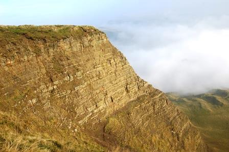
Do not follow the flagstone path down off Mam Tor. Instead follow the grassy path leading south. It’s easy to spot from the trig point. I usually stop quarter of the way down for lunch because the view is spectacular especially the cliff to the left. Follow the path to the bottom where you will meet the old A625 which is the old road that was destroyed by cliff erosion and subsidence. The first part of the road is obviously closed to cars; you usually find several gaggles of engineering students studying the effects of land erosion. Follow the road and you’ll come to a gate. Turn right after the gate and follow the road down the hill to Odin’s Mine. I usually carry a torch and the cave can make a nice retreat for a dry cup of tea.
 |
Just after Odin’s mine on the left hand side of the road you’ll find some steps going towards the millstone monument (Crushing Circle). Follow the path over the stream and follow to Knowlegates farm. You’ll see the path over their drive, follow the footpath to Castleton. Take a little peak behind you and you’ll see the route you have taken. |
When you come to the end of the field there is an enclosed path (a very narrow enclosed path) which brings you onto the A617. Turn left and it takes you back to the car park - The start of the Lose Hill Walk.
If you wanted a scenic route home you could drive up the A617 passed the thin passage way you finished the walk at. Follow the road up hill and turn left to Chapel on the Frith. Follow “Arthur’s Way to winnats pass". You pass Speedwell Cavern (Well worth a visit) with a car park opposite. Continue to the junction and turn right to Chapel on the Frith and Blue John Cavern. At the sharp bend you’ll see the right turn to The Blue John Caves. This also takes you to the collapsed road you walked down earlier.
|
Anyway continue up the road. You’ll come to some woods and a car park on the right. Pass these and take the right turn to Edale. This road will take you past Mam Tour and down a spectacular hill to Edale. Well done and I hope you have enjoyed the lose hill walk as much as we did. |
 |
Move from our Lose Hill Walk page to our Walks near Castleton page